


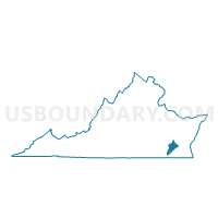
Raynor Voting District, Isle of Wight County, Virginia
About
Outline

Summary
| Unique Area Identifier | 681961 |
| Name | Raynor Voting District |
| County | Isle of Wight County |
| State | Virginia |
| Area (square miles) | 34.72 |
| Land Area (square miles) | 34.01 |
| Water Area (square miles) | 0.71 |
| % of Land Area | 97.94 |
| % of Water Area | 2.06 |
| Latitude of the Internal Point | 36.95513480 |
| Longtitude of the Internal Point | -76.80151980 |
Maps


Graphs
Select a template below for downloading or customizing gragh for Raynor Voting District, Isle of Wight County, Virginia


Neighbors
Neighoring Voting District (by Name) Neighboring Voting District on the Map
- Bacon's Castle Voting District, Surry County, VA
- Courthouse Voting District, Isle of Wight County, VA
- Ivor Voting District, Southampton County, VA
- Pons Voting District, Isle of Wight County, VA
- Wall's Bridge Voting District, Surry County, VA
- Zuni Voting District, Isle of Wight County, VA
Top 10 Neighboring County Subdivision (by Population) Neighboring County Subdivision on the Map
- Windsor district, Isle of Wight County, VA (6,668)
- Hardy district, Isle of Wight County, VA (6,470)
- Carrsville district, Isle of Wight County, VA (6,095)
- Berlin and Ivor district, Southampton County, VA (2,984)
- Bacons Castle district, Surry County, VA (1,443)
- Dendron district, Surry County, VA (1,370)
Top 10 Neighboring Unified School District (by Population) Neighboring Unified School District on the Map
- Isle of Wight County Public Schools, VA (35,270)
- Southampton County Public Schools, VA (18,570)
- Surry County Public Schools, VA (7,058)
Top 10 Neighboring State Legislative District Lower Chamber (by Population) Neighboring State Legislative District Lower Chamber on the Map
Top 10 Neighboring State Legislative District Upper Chamber (by Population) Neighboring State Legislative District Upper Chamber on the Map
Top 10 Neighboring 111th Congressional District (by Population) Neighboring 111th Congressional District on the Map
Top 10 Neighboring Census Tract (by Population) Neighboring Census Tract on the Map
- Census Tract 2803, Isle of Wight County, VA (5,490)
- Census Tract 2001, Southampton County, VA (4,251)
- Census Tract 2802, Isle of Wight County, VA (3,791)
- Census Tract 8602, Surry County, VA (3,651)